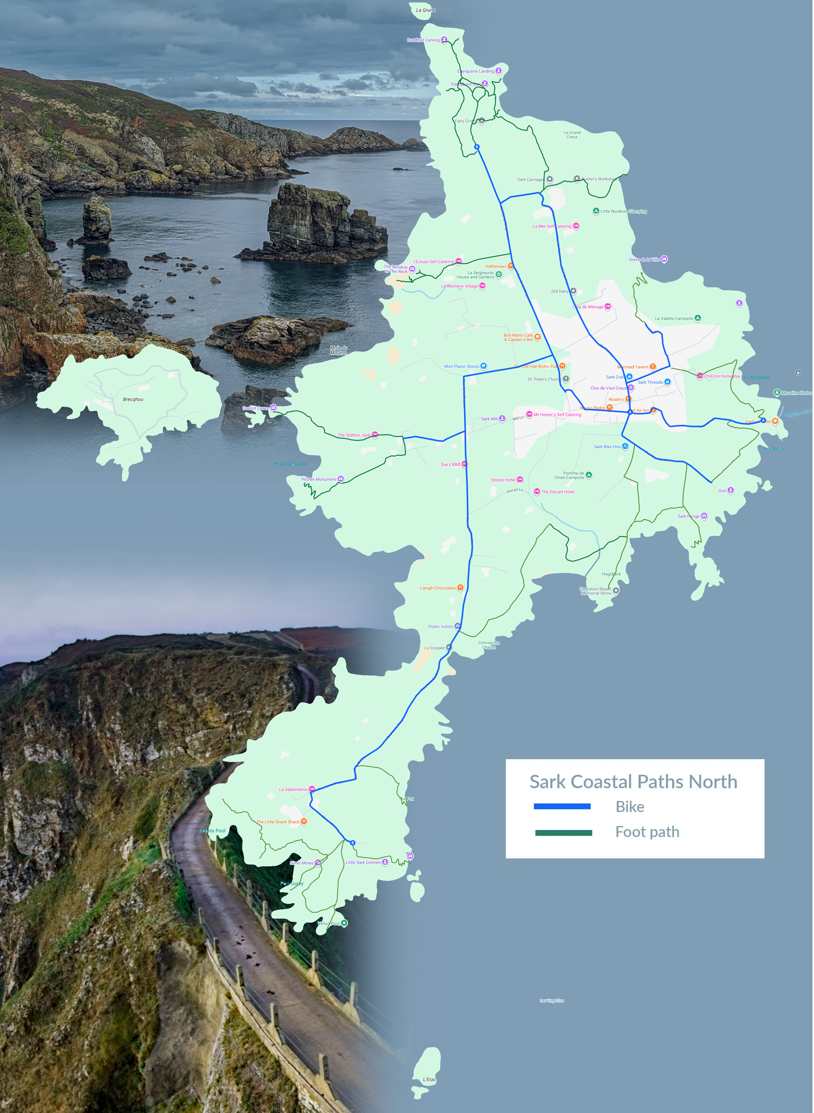
Derrible Bay (East coast)
One of the most beautiful bays on the island, though not the easiest to reach — a steep scramble down rewards you with golden sand at low tide, sea caves, and a huge open creux. At high tide the rocky platform at the cliff base is a perfect swimming spot. Almost never crowded.
Dixcart Bay (East coast)
The most accessible bay and Sark's most popular, yet still remarkably quiet. A pleasant walk through Dixcart woods leads down to a mix of sand, pebbles, rock pools and caves. The best anchorage on the island. Victor Hugo was reportedly a regular at the hotel in the valley above.
La Grande Grève (West coast, below La Coupée)
Sark's grandest beach, reached by 360 steps down from the La Coupée isthmus. Crystal-clear water, wide sandy expanse, and rock pools. Locals rate it the finest beach on the island.
Havre Gosselin (West coast)
A small sheltered harbour with vivid blue-green water. The path up to the Pilcher Monument above gives panoramic views across Brecqhou, Herm, Jethou and Guernsey. The narrow Gouliot Passage between Sark and Brecqhou nearby produces fierce tidal races.
Grève de la Ville (East coast, below Pointe Robert lighthouse)
A north-east facing bay close to the village, catching morning sun and bathed in light until midday. An early morning high-tide swim here is hard to beat, and it's just five minutes back up to the village.
L'Éperquerie (North tip)
The original landing spot for boats before the harbours existed. A small pebbly beach with a semi-natural tidal pool beside it, ideal for children. Around the corner, Les Fontaines has smooth boulders, shimmering green water and a sea arch worth snorkelling through.
Venus Pool (Little Sark — southern tip)
Sark's best-kept secret. A natural seawater pool carved into the rock at the southernmost tip of Little Sark, deep enough to swim and dive in. Only reachable for about four hours a day around low tide, so timing your walk matters.
Port du Moulin (West coast)
Below the famous Window in the Rock — a tunnel blasted through the cliff by an eccentric Victorian seigneur purely for the view. The bay below has sea stacks and caves that flood and drain with the tide.
Port Gorey (Little Sark)
The site of Sark's 19th-century silver and copper mines, where Cornish miners once worked four shafts, some extending under the seabed. Today only crumbling ventilation chimneys remain — ruined industry on a wild Atlantic headland.
Creux Harbour (East coast — main arrival point)
Reached through a tunnel cut through solid rock, with a second shorter tunnel through the headland to the north. The small beach is a popular swimming spot and a great place to get your bearings on arrival.
The Full Coastal Circuit — Full day, moderate 17.3km around the entire island.
Start at Creux Harbour, follow the cliff tops south through Derrible and Dixcart, cross La Coupée to Little Sark, and loop back via the Gouliot Headland. Farmland, cliffs, hidden bays and headlands all the way round. La Coupée & Little Sark — Half day, easy to moderate The narrow isthmus connecting Great Sark to Little Sark: three metres wide with 80-metre drops on either side. The path and railings were built by German prisoners of war in 1945. Cross over, visit Port Gorey's mine ruins, and descend to the Venus Pool.
The Hog's Back & WWII Memorial — 1 to 2 hours, easy
A narrow ridge walk between Derrible and Dixcart Bays. An old cannon sits in the grass at the end. A memorial nearby marks the spot associated with Major Appleyard's 1942 commando raid on the German-occupied island. Views across both bays in each direction.
Gouliot Headland at Sunset 1 hour from the village
Sark's westernmost point, overlooking Brecqhou. An internationally important wildlife site — rare sand crocus in spring, and sea caves below carpeted in anemones, soft corals and sea squirts. The sun sets behind Guernsey from here on clear evenings.
L'Éperquerie Common — Northern Cape — 1 to 2 hours, easy
L'Eperquerie marks the northern tip of Sark, and is embellished by a Buddhist rock carving inscribed in the year 2000. It remains a striking headland with dramatic coastal views. The name *esperquerie* is preserved in both Guernsey and Sark, and is thought to derive from the method of drying conger by erecting stakes or poles measuring one perch in length (*perques* or poles), on which a net was slung to hold the fish while it dried. Salt was needed for preservation.
Practical Tips
• Walk leaflets are free from the Sark Visitor Information Centre. The free map only shows main paths — a local guide is worthwhile for the secret swimming spots.
• The coast path is unmarked but easy to follow in good conditions.
• Tides matter for several bays — Venus Pool and the caves at Port du Moulin are best at or around low water; most beaches swim well at any tide.
• Sark was the world's first dark-sky island (2011). If you can stay overnight, the Milky Way is visible end to end on clear nights.
Contact Sark Tourism
Sark Tourism Office
The Avenue
Tel: +44 (0) 1481 832345
Visit Website